Google-backed wildfire detection satellites launch as smoke blankets US, Canada
▼ Summary
– The first three FireSat satellites, backed by Google, launched on July 7, 2026, to detect wildfires in the U.S., Australia, and Europe by end of year.
– After a three-month testing period, the satellites will provide data to fire agencies, covering fire-prone regions at least twice daily.
– FireSat is the first satellite constellation designed specifically for wildfire detection, with over $15 million from Google and $26 million from the Bezos Earth Fund.
– Each satellite uses multispectral imaging to detect fires as small as 5×5 meters, a capability proven by a 2025 Protoflight satellite that spotted low-intensity blazes.
– Early adopters include fire agencies in California, Colorado, Australia, and Portugal, with plans for hourly global imagery by 2029 and 20-minute updates by the early 2030s.
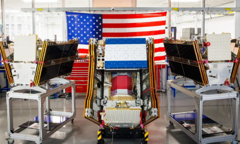
Smoke from hundreds of active wildfires continues to choke skies across Canada and the United States, but a new line of defense has just reached orbit. The first three operational satellites in the Google-backed FireSat program launched successfully aboard a SpaceX Falcon 9 rocket from California’s Vandenberg Space Force Base on July 7, 2026. This deployment marks the constellation’s shift to “initial operational capability,” a milestone that promises to transform how fire agencies detect and respond to blazes.
Managed by the nonprofit Earth Fire Alliance, these microsatellites will undergo a three-month testing phase before actively delivering data to firefighting teams. Once operational, the trio will scan every fire-prone region on Earth at least twice daily, covering the United States, Australia, and Europe. The goal is to spot even small fires before they explode into catastrophic infernos.
FireSat is the first satellite constellation purpose-built for wildfire detection. Unlike existing systems that often miss smaller or low-intensity blazes, these satellites carry multispectral imaging sensors designed to see through smoke and clouds. They can detect fires as small as five by five meters,roughly 16 by 16 feet. This capability was validated by a Protoflight satellite launched in March 2025, which captured over one million images and proved it could identify fires invisible to other orbital assets.
The constellation’s hardware was developed by California-based Muon Space, with Google contributing over $15 million to the initial deployment. Another major backer, the Bezos Earth Fund, has committed $26 million to the effort.
This year, “early adopter” fire agencies in California, Colorado, Australia, and Portugal will begin integrating FireSat data into their operations. As more satellites join the network, the program aims to refresh imagery for any location on Earth every hour by 2029. That cadence could accelerate to just 20 minutes once the full constellation,more than 50 satellites,is in place by the early 2030s. For communities living under a blanket of smoke, that speed can’t come soon enough.
(Source: Ars Technica)