Google Earth Now Lets You Time Travel with Old Street View
▼ Summary
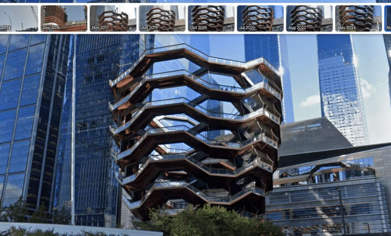
– Google Earth now allows users to view historical Street View imagery, showing how locations have changed over time, as part of its 20th-anniversary update.
– The feature enables users to browse images from different years, similar to the functionality already available in Google Maps.
– Last year, Google expanded access to historical satellite and aerial imagery, previously limited to the Earth Pro desktop app.
– Google plans to introduce AI-driven insights for professionals, including data on tree canopy coverage to identify shaded areas and potential cooling needs.
– The upcoming update will also provide land surface temperature data, helping professionals analyze urban heat patterns, with rollout expected in the coming weeks.
Exploring the past just got easier with Google Earth’s latest update, which introduces historical Street View imagery alongside powerful new environmental insights. This enhancement arrives as part of the platform’s 20th-anniversary celebrations, giving users a unique way to witness how neighborhoods, cities, and landscapes have transformed over time.
Previously, Google Earth allowed seamless switching between satellite views and Street View, but the addition of time-lapse functionality takes it further. Now, anyone can scroll through years of archived street-level photos, similar to the feature already available in Google Maps. Last year, the company expanded access to historical satellite imagery beyond its Earth Pro desktop app, making these visual records available to a broader audience.
Beyond nostalgia, the update brings practical tools for professionals. Google plans to introduce AI-powered analytics that reveal critical environmental data, such as tree canopy density and land surface temperatures. Urban planners, researchers, and sustainability experts can leverage this information to identify heat-prone zones or areas needing more greenery. These insights, expected in the coming weeks, could support smarter city planning and climate resilience efforts.
The combination of time-traveling Street View and advanced environmental metrics positions Google Earth as more than just a mapping tool, it’s becoming a dynamic resource for understanding our planet’s past and shaping its future. Whether you’re reminiscing about a childhood neighborhood or analyzing urban heat islands, these features open up new ways to explore and interact with the world.
(Source: The Verge)