Google Maps Adds AI ‘Ask Maps’ and 3D Immersive Navigation
▼ Summary
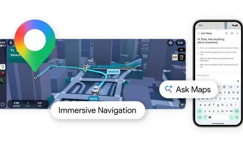
– Google has integrated its Gemini AI into Google Maps, introducing a new “Ask Maps” feature.
– This feature allows users to ask complex, real-world questions directly within the Maps application.
– It is designed to provide conversational assistance for planning trips and discovering places.
– The AI can handle multi-faceted queries, like finding specific types of restaurants in an area.
– The integration aims to make navigating and exploring with Google Maps more intuitive and helpful.
Navigating the world just got a lot smarter. Google has integrated its Gemini AI directly into Google Maps, introducing a powerful new feature called “Ask Maps.” This upgrade transforms the app from a simple navigation tool into an interactive assistant capable of handling complex, real-world queries. Imagine planning a day out and needing more than just directions. You could ask, “Find me a vintage clothing store in the city center that’s open late and has good reviews,” and Gemini will parse that multi-layered request to provide tailored suggestions. This move represents a significant shift towards more conversational and intuitive digital mapping.
The core of this innovation is the ability to understand natural language. Instead of manually filtering through categories and reading countless reviews, users can now ask questions as they would to a knowledgeable friend. The AI digs into Google’s vast database of local business information, photos, and user reviews to generate useful summaries and recommendations. It’s designed to help with detailed trip planning, whether you’re looking for a lunch spot that accommodates a large group and dietary restrictions or searching for activities that are fun for both kids and adults on a rainy day.
Alongside the AI chat feature, Google is rolling out an enhanced visual experience. A new “Immersive View” for routes provides a photorealistic, 3D preview of your entire journey before you even step outside. This isn’t just a static image; it’s a dynamic, multi-layered visualization. You can see your planned walking path overlaid on a lifelike streetscape, check anticipated traffic and weather conditions at your departure time, and even peek inside restaurants or cafes along the way using Street View and aerial imagery. This fusion of data aims to build user confidence and reduce pre-trip anxiety by offering a comprehensive sneak peek.
These features are built on advanced AI models that understand the visual world. The technology can analyze billions of Street View and aerial images to create rich, three-dimensional models of neighborhoods. This allows for the seamless blending of digital information with real-world visuals. For drivers, the update also includes more detailed lane guidance and real-time alerts for hazards like construction zones or sudden slowdowns, making complex highway interchanges easier to navigate.
The introduction of Gemini into Maps signals a broader trend of AI becoming deeply embedded in everyday applications. The goal is to save users time and mental energy by synthesizing information that would normally require multiple searches and app switches. While the “Ask Maps” feature is launching initially in the United States, the immersive navigation visuals are starting to become available in major cities like London, New York, Tokyo, and San Francisco. Google plans to expand access to these tools globally throughout the coming year, continually refining them based on how people use them in their daily lives.
(Source: Mac Rumors)